Monday 21 October 2013

Flood Alleviation Work on Bank Street


The church spires along the East side of the River Ness have recently been joined by the tall jib of a crane. This is just one of the many construction vehicles and plant working on Phase 1 of the River Ness Flood Alleviation Scheme.

This view is looking upstream from near the tidal opening to the sea.


The plan is to re-build and reinforce the banks on both sides of the River.
Much preparatory work was done earlier this year.
This construction phase started about a month ago.
The current work is on and around Bank Street.


My particular interest is the effect on cycling is.
So I took a trip going upstream starting from Douglas Row.
This is part of the NCN Route 1 going South and is normally one-way, access only and so has quite light traffic. It's also used by touring cyclists mainly in Summer.
The significance of the new "ROAD CLOSED" sign is simply that there is no exit for motor vehicles at the other end.


I rounded the corner into Douglas Row.
It's never that busy but it was noticeably more noisy with the work going on.
The river level is low just now but this street can be submerged when the river in spate meets back-flow from a high tide. The houses get flooded too, either directly through the doors or by water penetration through the floors from below.
One purpose of the scheme is to avoid such damage in the future.


The road at the end of Douglas Row is fenced off leaving only the pavement.
When I visited, the signs shown here were obscured behind a van.
In truth, the route is obvious so there is no real harm.
The construction site is very cramped.
Arrangements may not always be perfect but safety is maintained.


All three roads are fenced off at the junction with Friars Lane and Bank Street.
The pavement route goes around the corner from Douglas Row into Friars Lane then doubles back on the other side to the beginning of Bank Street.


The pavement route up Friars Lane narrows to less than a metre.
But none of this is of any great problem or concern to local cyclists.
The road to the left here is Friars Street which is open to one-way traffic.
This is also the North heading branch of NCN Route 1.


Doubling back down Friars Lane.
This carries NCN Route 1 in both directions.
Usually cycling, in either direction, would be on the road.
With a single pavement being the only route, all users have to be considerate.
And that seems to be what's happening.


Round the corner into Bank Street and the serious work begins.
Watching diggers and trucks is always an attraction.


This is roughly the same view from a higher view point.
The construction work had finished and was being reviewed by engineers.
Lots of Hi-Viz jackets in evidence at all times.

The Greig Street Bridge is a popular route across the River for pedestrian and cyclists.
The construction work seems to be having little or no effect on travellers.


Pedestrians and cyclists share the Bridge at a leisurely rate.
Cyclists are concerned with safety but dress for warmth.
Woolly bonnets are more common than cycling helmets.
Some pedestrians make a special effort with their appearance.


There was more work going on upstream of the Bridge.
The bank is being extended slightly at this point for a seating area.


The River Cafe and Restaurant is open as normal and even offers tables and chairs outside (for very hardy customers).


Highland Print Studio remains open for its usual classes and members.
Anybody is welcome to browse the prints they have on offer.
Print makers come here from all over the Highlands, Scotland and abroad.
One recent visitor was Mike Inglis whose output includes the mural near Eastgate.


The construction phase is under way but in among the noise and disturbance it's business as usual on Bank Street.


Your comments are welcome.

Saturday 12 October 2013

Bikes, Boats and Brambles


A few days ago I cycled to Dochgarroch which is about 5 miles (8 km) South West of Inverness.
This blog follows the tow-path on the South side of the Caledonian Canal back to Inveness.


Dochgarroch is a small, scattered settlement
whose main livelihood comes from tourist trade
from users of the Caledonian Canal.

This house doubles as a souvenir shop.
On display are potted plants, home baking and
these decorated Loch Ness Stones for £1 each.
Payment is by an honesty box - very relaxed.

Some people live in Dochgarroch but commute to work
in Inverness. Some also commute the other way.


Dochgarroch exists mainly because of its two lock gates on the Caledonian Canal.
A short distance further SW is the point where the Canal opens into Loch Dochfour which in turn opens into Loch Ness.
The overflow over the weir from Loch Dochfour is the main source of the River Ness.


The two lock gates are normally closed and only opened, one at a time, to allow boats through.

So there is always access for walkers or cyclists by at least one route.

(These views are both of the lock gate on the Inverness side.)


It's not unusual to find somebody rummaging in the bushes.

But it's nothing strange or sinister ...
... it's simply the bramble season.

Warning - The branches are extremely jabby!


Caledonian Canal

Bikes and boats
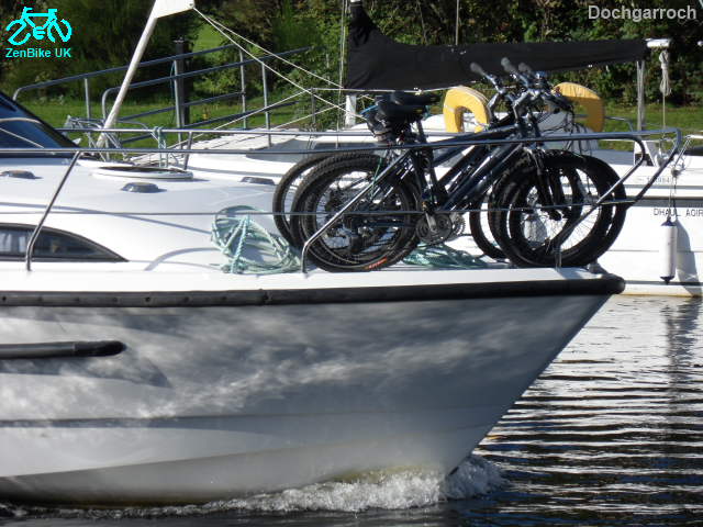
Bikes on boats

Dochgarroch has more boats than houses.

Many chooses to commute by bike along the canal tow-path.
Also popular with walkers with or without dogs.


(No bikes) just birds

The damp, woody environment at this time of year suits a variety of mushrooms ... and brambles.

Mushroom and bike
Mushroom clump
Mushroom 'ghost'


The middle stretch of the trip has a strong natural wilderness feel about it.

The quiet is occasionally disturbed by a convoy of boats making their way along the canal.

Exchanging friendly waves is quite common.


The path is a bit rough but well-maintained and suitable for tour cycling.

Hi-viz seems a bit out of place here although bike bells are appreciated, particularly by people walking their dogs.

Houses are rare but can be quite grand.


The bank widens to give a clear view of both the Caledonian Canal and the River Ness.

By this point the River is at a much lower level than the Canal. - No brambles here.

A little further to Tomnahurich Swing Bridge
(or Millerton as it is also known and easier to say)
and we've arrived at the A82 into Inverness.


So I'd made a round trip of 10 miles on a lovely day,
met some interesting people
and returned with a large bowl of fresh brambles
that I'll be having with my breakfast over the next few days.

I would be nice if everybody who cycles to work
could enjoy a similarly pleasant daily commute.

But I understand other experiences are available!


Your comments are welcome.


Monday 7 October 2013

Alison Johnstone MSP meets HCC Members


This weekend the Scottish Greens met for their 2013 Conference at Eden Court, Inverness. Alison Johnstone MSP was attending and kindly took time out to meet some members of the Highland Cycle Campaign (HCC).

The Highlands cover a large area but there were HCC representatives from all over.

Alison was keen to learn about some of the many issues concerning HCC.

[Pictured: Tess, Alison, ZenBike, Brian, Anne]


Dr Gus Jones (Strathspey)

  • New Housing Development. A local issue with national consequences where the interests of a small rural community are up against large business and the likely loser is the environment.

Brian MacKenzie (Inverness)

  • Flood Alleviation Scheme. The Highland Council has spent a lot of time preparing for this.The construction phase is just beginning.
  • The Golden Bridge. The one-piece 84 metre span of the bridge was lowered into position in April 2013.  Video (jump to 4:55). Opening date still unknown. Work continues on the end ramps and steps.
  • Prince Charlie Way. Part of this is planned to provide a cycle route connecting the City Centre to the Golden Bridge. Some ideas from HCC here.

Anne Thomas and Gerard Church (Black Isle)

  • Transition Black Isle. The Million Miles project focuses on safer, greener, more sociable travel. And cycling continues to be a particular success.
  • The Kessock Bridge Upgrade. Early in Phase 1 of the project, HCC provided detailed feedback of problems. The signage for cyclists (and pedestrians) was particularly misleading. Transport Scotland seemed to adopt a superior attitude and failed to engage in any genuine support of cycling policy. Touring cyclists were still getting lost as late as July 2013. It is hoped that Phase 2 will be better.

In addition, HCC is also active at a national level:

  • Cycling needs more realistic funding. The current cycling funding for the whole of Scotland is only 5% of a single project, dualling the A9. Whereas cycling should be 10% of the Transport budget.
  • Transport Scotland needs a dedicated team for cycling. This would include engineers with a professional understanding of quality cycle provision. The goal being real priority to encourage and increase all forms of cycling.
  • Stronger backing from Government to advance cycling. Government needs to get tough with landowners who stand in the way of cycle schemes for no good reason.


Your comments are welcome.